 bvermeulen
- posts: 175
bvermeulen
- posts: 175
Thailand 1714
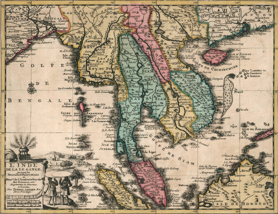
This image depicts a map titled “L’ Inde De ca Le Gange,” created by Pieter van der Aa in 1714. It is part of the “Nouvel Atlas, tres-exact et fort commode pour toutes sortes de personnes,” a collection of geographical maps. The map measures 30 cm in width and 23 cm in height.
Author: Aa, Pieter van der, 1659-1733
Date: 1714
Short Title: L’ Inde De ca Le Gange
Publisher: Chez Pierre Van der Aa
Publisher Location: Leiden
Type: Atlas Map
Obj Height cm: 23
Obj Width cm: 30
Scale 1: 12,100,000
Note: Full color map of South East Asia, Covers detailed map of Malaysia, Thailand, Indo-China, Sumatra, Borneo and Singapore. With decorative cartouche. Showing political and administrative boundaries. Relief shown pictorially. Reference: Philips, Geographical Atlases, Vol. IV, title 4277. Region: South East Asia Full Title: L' Inde De ca Le Gange, Suivant les nouvelles observations de Messrs ... A Leide, Chez Pierre Van der Aa. (to accompany) Nouvel Atlas, tres-exact et fort commode pour toutes sortes de personnes, Contenant les Principales Cartes Geographiques ... List No: 11691.098 Page No: 92 Series No: 98 Publication Author: Aa, Pieter van der, 1659-1733 Pub Date: 1714
Pub Title: Nouvel Atlas, tres-exact et fort commode pour toutes sortes de personnes, Contenant les Principales Cartes Geographiques. Dresse suivant les nouvelles observations de Mrs. de l'Academie Royale des Sciences, & rectifie sur les Relations les plus recentes des plus fideles voyageurs. A Leide, Chez Pierre Van der Aa, Marchand Libraire. Avec Privilege. Pub Reference: Philips, Geographical Atlases, Vol. IV, title 4277.
Pub Note: Van de Aa describes this book as a new atlas, which contains the principal geographical maps of modern long-journey voyages which have been made both by sea and by land in all parts of the world, and of the most famous routes for travelers from the year 1246 to 1696, drawn up according to the new observations of members of the Royal Academy of Sciences. Includes engraved hand colored pictorial title and dedication plates; 2 pages of introductory text “Avis au lecteur”, 4 pages of descriptive text; La Nouvelle Geographie Aisee, and manuscript index "Table des Nouvelles carte geographiques ...". Manuscript date "1686" on frontispiece. Pages numbered also in manuscript, 5-100, 98 maps numbered in manuscript, 6-100. Map number 46 is in 3 parts, 46A-46C. Maps are engraved and hand colored. There are many decorative title cartouches, including figures, cherubs, fauna and views. Showing political and administrative boundaries, major cities, towns, villages, rivers, lakes, landmarks, roads, forests and mountains. Relief shown pictorially. Some maps includes compass rose and notations. Bound in full leather covers, with Title "Atlas" embossed in gilt on spine. Pieter van der Aa, a Dutch publisher and printer was best known for his cartographic work. He opened a bookshop and publishing house in Leiden in 1677, and started his first business there in 1683. By 1694 he was made printer to Leiden University, and by 1715, he was appointed the official printer to the town of Leiden. His major work was the massive Galerie Agreable du Monde (1729) a compendium of some 3,000 plates in 66 volumes, published in an edition of 100 sets. Other publications included Atlas Nouveau et Curieux and Atlas Nouvel, both produced in 1714. Van der Aa also produced separately issued maps and reissued maps by other publishers, such as Les Forces de l’Europe (1726), originally published in 1696 by Nicolas de Fer. Pub List No: 11691.000 Pub Type: World Atlas Pub Maps: 98 Pub Height cm: 31 Pub Width cm: 40 Image No: 11691098.jp2 Download 1: Full Image Download… Download 2: GeoViewer for JP2 and SID files Authors: Aa, Pieter van der, 1659-1733
bvermeulen
- posts: 175
Swolla
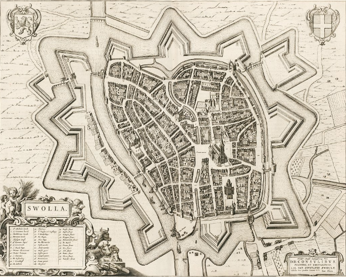
The work depicted is a map titled “Swolla,” created by Joan Blaeu and Willem Janszoon Blaeu in 1652. It is part of the renowned atlas “Toonneel der Steeden van s’Konings Nederlanden, met hare Beschryvingen”
Author: Blaeu, Joan, 1596-1673
Author: Blaeu, Willem Janszoon, 1571-1638
Date: 1652
Short Title: Swolla
Publisher: Joan Blaeu
Publisher Location: Amsterdam
Type: Atlas Map
Obj Height cm: 56
Obj Width cm: 66
Note: Volume One. Dimensions are sheet size.
Country: Netherlands
City: Zwolle (Netherlands)
Full Title: Swolla
List No: 16224.197
Page No: 189
Series No: 197
Publication Author: Blaeu, Joan, 1596-1673
Publication Author: Blaeu, Willem Janszoon, 1571-1638
Pub Date: 1652
bvermeulen
- posts: 175
Netherlands railroad map 1905
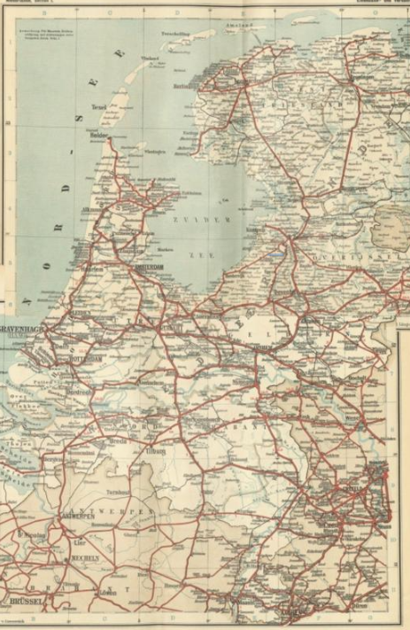
The image depicts a composite map from the “Eisenbahn und verkehrsatlas von Europa,” specifically focusing on the Netherlands. This map is part of a larger atlas published in 1905 by J.J. Arnd in Leipzig, edited by C. Opitz and founded by Wilhelm Koch and C. Opitz.
Author: Koch, Wilhelm
Author: Opitz, C.
Date: 1905
Short Title: Composite Map: Section 1-2. Niederland
Publisher: J. J. Arnd (Leipzig)
Publisher Location: Leipzig
Type: Composite Map
Obj Height cm: 56
Obj Width cm: 40
Scale 1: 2,000,000